


中颱杜蘇芮逼近 最快今晚海警、明天陸警
2023-7-24 編輯部/綜合報導
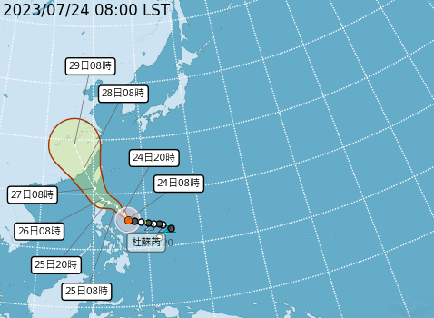
預估杜蘇芮週三、週四對台影響最大(圖_取自中央氣象局)。
颱風持續逼近!根據中央氣象局資料顯示,今日凌晨2時颱風中心位置鵝鑾鼻東南方海面,北緯 15.2 度,東經 127.0 度。以每小時8公里速度,向西北進行。中心氣壓965百帕,近中心最大風速每秒35公尺,瞬間最大陣風每秒 45 公尺。
中央氣象局指出,杜蘇芮強度持續增強,暴風圈半徑擴大至250公里。今天移動速度加快往西北,路徑往南調整,預測中心沒登陸本島,由西南部近海通過。預估今晚發海警、周二中午前陸警,接近台灣時強度達中颱上限,甚至更強。請民眾及早做好防颱準備,並隨時留意颱風訊息。
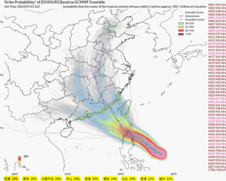
ECMWF(歐洲中長期天氣預報中心)颱風系集圖(圖_翻攝自網路)。
針對杜蘇芮颱風路徑預測,吳德榮指出,歐洲模式模擬的「系集平均路徑」往南調整,從菲律賓東方海面,向西北前進,經巴士海峽,通過台灣海峽南部。美國模式的系集平均路徑也往南調整,閃過台灣、通過台灣西南部近海。
氣象主播林嘉愷表示,雖然颱風路徑再南修,中心登陸機會降低,但可能經南部近海及金門往中國,暴風圈仍會掃過台灣。除非路徑再南偏,中心經過菲國北部陸地,這樣暴風圈可能稍掠過南台灣。目前路徑變化仍大,還要再觀察。週三愈晚風雨越大,持續至週四。週五起颱風遠離,但各地仍有局部與。週六起恢復夏季型天氣,午後局部雷陣雨。


First of all I want to say awesome blog! I had a quick question which I’d like to
ask if you don’t mind. I was curious to know how you center yourself
and clear your head prior to writing. I have had a
tough time clearing my thoughts in getting my thoughts out.
I truly do enjoy writing but it just seems like the first 10 to 15 minutes are generally wasted simply just
trying to figure out how to begin. Any ideas or hints?
Thanks!
I think the admin of this site is actually working hard in favor of his web site, since here every material
is quality based material.